
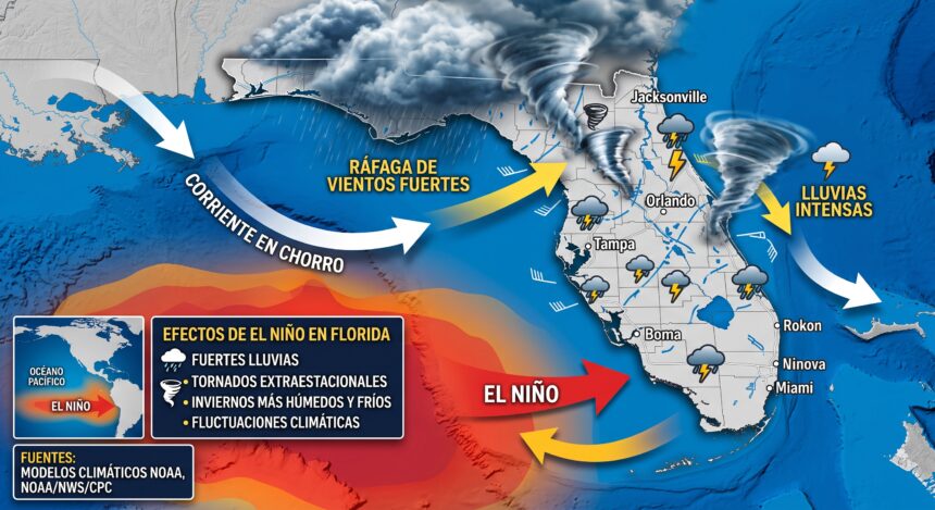
El Niño enters a critical phase with over 90% probability of reaching strong category. Learn about its effects on Florida and how to prepare.
The latest climate update anticipates an exceptional episode in the coming months, warning of drastic changes in global atmospheric patterns.

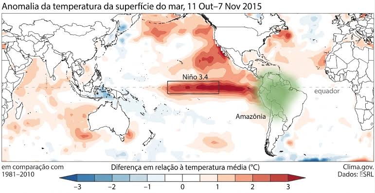
Temperature anomalies in the Pacific due to El Niño. Source: OTCA
The Climate Prediction Center has issued a strong warning: the current El Niño phenomenon is rapidly evolving into a critical phase.
According to the latest weather models, there is over a 90% probability that this event will reach an intensity classified as “very strong” or “historic” during the upcoming winter.
This anomalous warming of waters in the equatorial Pacific Ocean will not only alter marine temperatures but also trigger a chain reaction in the atmosphere, modifying rainfall, wind, and temperature patterns globally.

Meteorologists anticipate an exceptional episode that requires immediate attention and preventive measures.
How will this phenomenon affect the state of Florida?
While El Niño causes extreme droughts in some regions of the world, in the southeastern United States, and particularly in Florida, the effects are notably different and come with their own risks.
If the event reaches the expected intensity, Florida residents can expect:

- Colder and wetter winters: The subtropical jet stream typically shifts further south during a strong El Niño event. This injects more moisture and consistent cold fronts into the Gulf of Mexico, resulting in a winter with below-average temperatures and abundant rainfall.
- Increased risk of severe weather: Historically, El Niño winters in Florida see a significant rise in squall lines and tornadoes out of season. The combination of cold air aloft and Gulf moisture creates a highly unstable environment.
- Localized sea-level rise (Flooding): Disruptions in ocean winds and continuous low atmospheric pressure can worsen king tides, increasing the risk of coastal flooding even without a hurricane.
- Impact on hurricane season: The only “positive” effect of El Niño for Florida is that its strong wind shear in the Atlantic tends to inhibit hurricane formation during summer and fall. However, experts warn that just one storm making landfall can make the season disastrous.
Preparation Guide: What Can We Do?
Given the imminent threat of more severe and rainy weather in the coming months, prevention is the best tool. Here’s how to be prepared:
- Review insurance policies: Make sure your home insurance includes flood coverage. Many standard policies do not, and El Niño’s winter rains can overwhelm drainage systems.
- Home maintenance:
- Clean gutters, downspouts, and drains to prevent water buildup.
- Inspect the roof for leaks or loose shingles before continuous rains begin.
- Prune trees near your property; winter storms often come with strong wind gusts.
- Family emergency plan: Just like during hurricane season, keep a basic supplies kit (water, non-perishable food, flashlights, spare batteries, and a first-aid kit) on hand in case of power outages caused by thunderstorms.
- Tornado alert: Given the increased risk of winter tornadoes, ensure you have a way to receive weather alerts (a NOAA radio or apps on your phone with notifications enabled) and designate an interior, windowless room as a shelter in your home.
Authorities urge the public not to let their guard down. While winter in Florida is usually synonymous with good weather, the influence of a “Super El Niño” promises to change the game this year.