
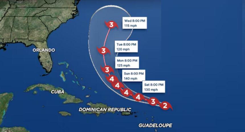
Even though it won’t make direct landfall, Hurricane Erin is expected to significantly impact any beach plans in South Florida this weekend, making beach trips extremely dangerous and not recommended.
While the center of Hurricane Erin, a powerful Category 4 storm, will remain at sea, its effects will be felt along Florida’s entire east coast. Meteorologists from the National Hurricane Center warn of coastal conditions that will pose a life-threatening risk.

Calm conditions along the Treasure Coast are expected to change drastically next week as Hurricane Erin generates strong waves and dangerous rip currents throughout the region.
The storm, currently moving through the Atlantic, is not forecast to make landfall but will still create waves—literally—for local surfers and swimmers.
Main Beach Hazards
- Rip Currents: This will be the most widespread and significant danger. The hurricane is generating strong swells in the Atlantic, creating powerful and deadly rip currents. These currents can pull even the strongest swimmers out to sea. A high risk of rip currents is expected all week, including the weekend.
- High and Dangerous Waves: Waves are forecast to increase significantly as Erin approaches, potentially reaching 5 to 8 feet in height. These waves are not only dangerous for swimmers but will also cause considerable beach erosion.
- Coastal Flooding: The combination of high waves and tides could lead to minor flooding in low-lying coastal areas and boardwalks.
Recommendations and Closures
Currently, there are no hurricane warnings for South Florida since the storm will not make landfall. However, emergency management authorities and weather services have issued high surf and rip current warnings.
Local authorities are likely to restrict water access and close beach sections for safety. Even if skies along the coast appear sunny, conditions in the water will be deceptively dangerous.

In short, you should completely cancel your beach plans this weekend. Swimming or even being near the shore will not be safe due to the extreme risk of rip currents and high waves generated by Hurricane Erin.